East and Southeast Asia / PG
Spratly Islands
Last updated: October 29, 2026
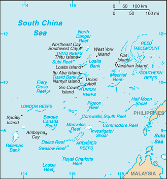
Map image could not be loaded. Open source image.
ⓘ
CIA World Factbook map, February 2021 media edition. Identity reviewed; current boundaries have not been audited. visual contact sheet or original identity check; does not verify current boundaries Boundaries, place names and designations may be dated or disputed; original annotations retained. SHA-256: de017f51cac4b208c78634d561a06539d5a12c857b6a7ef8488c02de42fa010c. Provenance and inspection record.Introduction
Background:1
The Spratly Islands consist of more than 100 small islands or reefs surrounded by rich fishing grounds -- and potentially by gas and oil deposits. China, Taiwan, and Vietnam all claim the islands in their entirety, while portions are claimed by Malaysia and the Philippines. Around 70 disputed islets and reefs in the Spratly Islands are occupied by China, Malaysia, the Philippines, Taiwan, and Vietnam. Since 1985, Brunei has claimed a continental shelf that overlaps a southern reef but has not made any formal claim to the reef. Brunei claims an exclusive economic zone over this area.
Geography
Location:2
Southeastern Asia, group of reefs and islands in the South China Sea, about two-thirds of the way from southern Vietnam to the southern Philippines
Geographic coordinates:3
8 38 N, 111 55 E
Map references:4
Southeast Asia
Area:5
Area - comparative:6
land area is about seven times the size of the National Mall in Washington, D.C.
Land boundaries:7
Coastline:8
926 km
Climate:9
tropical
Terrain:10
small, flat islands, islets, cays, and reefs
Elevation:11
Natural resources:12
fish, guano, undetermined oil and natural gas potential
Land use:13
Natural hazards:14
typhoons; numerous reefs and shoals pose a serious maritime hazard
Geography - note:15
strategically located near several primary shipping lanes in the central South China Sea; includes numerous small islands, atolls, shoals, and coral reefs
People and Society
Population:16
Environment
Environmental issues:17
harm to reefs from China's use of dredged sand and coral to build artificial islands; illegal fishing practices
Climate:18
tropical
Land use:19
Government
Country name:20
Military and Security
Military - note:21
around 70 disputed islets and reefs in the Spratly Islands are occupied by China, Malaysia, the Philippines, Taiwan, and Vietnam
Philippines: occupies nine features (Commodore Reef, Second Thomas Shoal, Flat Island, Loaita Cay, Loaita Island, Nanshan Island, Northeast Cay, Thitu Island, and West York Island); Thitu Island has an airstrip and a coast guard station
Notes & sources
- Background. Reference edition; observation: dates as stated in text. Field last updated: not supplied; profile fallback: 2025-08-27 11:22:08 -0400 (not a field revision date); needs review. Reference source. Edition last checked 2026-10-29 (retrieval only). ↩
- Location. Reference edition; observation: dates as stated in text. Field last updated: not supplied; profile fallback: 2025-08-27 11:22:08 -0400 (not a field revision date); needs review. Reference source. Edition last checked 2026-10-29 (retrieval only). ↩
- Geographic coordinates. Reference edition; observation: dates as stated in text. Field last updated: not supplied; profile fallback: 2025-08-27 11:22:08 -0400 (not a field revision date); needs review. Reference source. Edition last checked 2026-10-29 (retrieval only). ↩
- Map references. Reference edition; observation: dates as stated in text. Field last updated: not supplied; profile fallback: 2025-08-27 11:22:08 -0400 (not a field revision date); needs review. Reference source. Edition last checked 2026-10-29 (retrieval only). ↩
- Area. Reference edition; observation: dates as stated in text. Field last updated: not supplied; profile fallback: 2025-08-27 11:22:08 -0400 (not a field revision date); needs review. Reference source. Edition last checked 2026-10-29 (retrieval only). ↩
- Area - comparative. Reference edition; observation: dates as stated in text. Field last updated: not supplied; profile fallback: 2025-08-27 11:22:08 -0400 (not a field revision date); needs review. Reference source. Edition last checked 2026-10-29 (retrieval only). ↩
- Land boundaries. Reference edition; observation: dates as stated in text. Field last updated: not supplied; profile fallback: 2025-08-27 11:22:08 -0400 (not a field revision date); needs review. Reference source. Edition last checked 2026-10-29 (retrieval only). ↩
- Coastline. Reference edition; observation: dates as stated in text. Field last updated: not supplied; profile fallback: 2025-08-27 11:22:08 -0400 (not a field revision date); needs review. Reference source. Edition last checked 2026-10-29 (retrieval only). ↩
- Climate. Reference edition; observation: dates as stated in text. Field last updated: not supplied; profile fallback: 2025-08-27 11:22:08 -0400 (not a field revision date); needs review. Reference source. Edition last checked 2026-10-29 (retrieval only). ↩
- Terrain. Reference edition; observation: dates as stated in text. Field last updated: not supplied; profile fallback: 2025-08-27 11:22:08 -0400 (not a field revision date); needs review. Reference source. Edition last checked 2026-10-29 (retrieval only). ↩
- Elevation. Reference edition; observation: dates as stated in text. Field last updated: not supplied; profile fallback: 2025-08-27 11:22:08 -0400 (not a field revision date); needs review. Reference source. Edition last checked 2026-10-29 (retrieval only). ↩
- Natural resources. Reference edition; observation: dates as stated in text. Field last updated: not supplied; profile fallback: 2025-08-27 11:22:08 -0400 (not a field revision date); needs review. Reference source. Edition last checked 2026-10-29 (retrieval only). ↩
- Land use. Reference edition; observation: dates as stated in text. Field last updated: not supplied; profile fallback: 2025-08-27 11:22:08 -0400 (not a field revision date); needs review. Reference source. Edition last checked 2026-10-29 (retrieval only). ↩
- Natural hazards. Reference edition; observation: dates as stated in text. Field last updated: not supplied; profile fallback: 2025-08-27 11:22:08 -0400 (not a field revision date); needs review. Reference source. Edition last checked 2026-10-29 (retrieval only). ↩
- Geography - note. Reference edition; observation: dates as stated in text. Field last updated: not supplied; profile fallback: 2025-08-27 11:22:08 -0400 (not a field revision date); needs review. Reference source. Edition last checked 2026-10-29 (retrieval only). ↩
- Population. Reference edition; observation: dates as stated in text. Field last updated: not supplied; profile fallback: 2025-08-27 11:22:08 -0400 (not a field revision date); needs review. Reference source. Edition last checked 2026-10-29 (retrieval only). ↩
- Environmental issues. Reference edition; observation: dates as stated in text. Field last updated: not supplied; profile fallback: 2025-08-27 11:22:08 -0400 (not a field revision date); needs review. Reference source. Edition last checked 2026-10-29 (retrieval only). ↩
- Climate. Reference edition; observation: dates as stated in text. Field last updated: not supplied; profile fallback: 2025-08-27 11:22:08 -0400 (not a field revision date); needs review. Reference source. Edition last checked 2026-10-29 (retrieval only). ↩
- Land use. Reference edition; observation: dates as stated in text. Field last updated: not supplied; profile fallback: 2025-08-27 11:22:08 -0400 (not a field revision date); needs review. Reference source. Edition last checked 2026-10-29 (retrieval only). ↩
- Country name. Reference edition; observation: dates as stated in text. Field last updated: not supplied; profile fallback: 2025-08-27 11:22:08 -0400 (not a field revision date); needs review. Reference source. Edition last checked 2026-10-29 (retrieval only). ↩
- Military - note. Reference edition; observation: 2025. Field last updated: not supplied; profile fallback: 2025-08-27 11:22:08 -0400 (not a field revision date); needs review. Reference source. Edition last checked 2026-10-29 (retrieval only). ↩