Antarctica / BV
Bouvet Island

ⓘ
2021 Factbook flag mirror; image identity has not been individually audited. Source.
Last updated: October 29, 2026
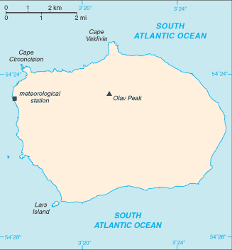
Map image could not be loaded. Open source image.
ⓘ
CIA World Factbook map, February 2021 media edition. Identity reviewed; current boundaries have not been audited. visual contact sheet or original identity check; does not verify current boundaries Boundaries, place names and designations may be dated or disputed; original annotations retained. SHA-256: 80369b22d5a3284e18bb61f9026ae4922f7f21b6491277a7ae205185b6a7a636. Provenance and inspection record.Introduction
Background:1
This uninhabited volcanic island in Antarctica is almost entirely covered by glaciers, making it difficult to approach. Bouvet Island is recognized as the most remote island on Earth because it is furthest from any other point of land (1,639 km from Antarctica). The island was named after the French naval officer who discovered it in 1739, although no country laid claim to it until 1825, when the British flag was raised. A few expeditions visited the island in the late 19th century. In 1929, the UK waived its claim in favor of Norway, which had occupied the island two years previously. In 1971, Norway designated Bouvet Island and the adjacent territorial waters as a nature reserve. Since 1977, Norway has run an automated meteorological station and studied foraging strategies and distribution of fur seals and penguins on the island. In 2006, an earthquake weakened the station's foundation, causing it to be blown out to sea in a winter storm. Norway erected a new research station in 2014 that can hold six people for periods of two to four months.
Geography
Location:2
island in the South Atlantic Ocean, southwest of the Cape of Good Hope (South Africa)
Geographic coordinates:3
54 26 S, 3 24 E
Map references:4
Antarctic Region
Area:5
Area - comparative:6
about 0.3 times the size of Washington, D.C.
Land boundaries:7
Coastline:8
29.6 km
Maritime claims:9
Climate:10
antarctic
Terrain:11
volcanic; coast is mostly inaccessible
Elevation:12
Natural resources:13
none
Land use:14
Natural hazards:15
occasional volcanism, rock slides; harsh climate, surrounded by pack ice in winter
Geography - note:16
almost entirely covered by glacial ice (93%); declared a nature reserve by Norway; the distance from Bouvet Island to Norway is 12,776 km, which is almost one-third the circumference of the earth
People and Society
Population:17
Environment
Climate:18
antarctic
Land use:19
Government
Country name:20
Dependency status:21
territory of Norway; administered by the Polar Department of the Ministry of Justice and Oslo Police
Legal system:22
the laws of Norway apply
Flag:23
the flag of Norway is used
Communications
Internet country code:24
.bv
Notes & sources
- Background. Reference edition; observation: dates as stated in text. Field last updated: not supplied; profile fallback: 2025-09-29 10:40:23 -0400 (not a field revision date); needs review. Reference source. Edition last checked 2026-10-29 (retrieval only). ↩
- Location. Reference edition; observation: dates as stated in text. Field last updated: not supplied; profile fallback: 2025-09-29 10:40:23 -0400 (not a field revision date); needs review. Reference source. Edition last checked 2026-10-29 (retrieval only). ↩
- Geographic coordinates. Reference edition; observation: dates as stated in text. Field last updated: not supplied; profile fallback: 2025-09-29 10:40:23 -0400 (not a field revision date); needs review. Reference source. Edition last checked 2026-10-29 (retrieval only). ↩
- Map references. Reference edition; observation: dates as stated in text. Field last updated: not supplied; profile fallback: 2025-09-29 10:40:23 -0400 (not a field revision date); needs review. Reference source. Edition last checked 2026-10-29 (retrieval only). ↩
- Area. Reference edition; observation: dates as stated in text. Field last updated: not supplied; profile fallback: 2025-09-29 10:40:23 -0400 (not a field revision date); needs review. Reference source. Edition last checked 2026-10-29 (retrieval only). ↩
- Area - comparative. Reference edition; observation: dates as stated in text. Field last updated: not supplied; profile fallback: 2025-09-29 10:40:23 -0400 (not a field revision date); needs review. Reference source. Edition last checked 2026-10-29 (retrieval only). ↩
- Land boundaries. Reference edition; observation: dates as stated in text. Field last updated: not supplied; profile fallback: 2025-09-29 10:40:23 -0400 (not a field revision date); needs review. Reference source. Edition last checked 2026-10-29 (retrieval only). ↩
- Coastline. Reference edition; observation: dates as stated in text. Field last updated: not supplied; profile fallback: 2025-09-29 10:40:23 -0400 (not a field revision date); needs review. Reference source. Edition last checked 2026-10-29 (retrieval only). ↩
- Maritime claims. Reference edition; observation: dates as stated in text. Field last updated: not supplied; profile fallback: 2025-09-29 10:40:23 -0400 (not a field revision date); needs review. Reference source. Edition last checked 2026-10-29 (retrieval only). ↩
- Climate. Reference edition; observation: dates as stated in text. Field last updated: not supplied; profile fallback: 2025-09-29 10:40:23 -0400 (not a field revision date); needs review. Reference source. Edition last checked 2026-10-29 (retrieval only). ↩
- Terrain. Reference edition; observation: dates as stated in text. Field last updated: not supplied; profile fallback: 2025-09-29 10:40:23 -0400 (not a field revision date); needs review. Reference source. Edition last checked 2026-10-29 (retrieval only). ↩
- Elevation. Reference edition; observation: dates as stated in text. Field last updated: not supplied; profile fallback: 2025-09-29 10:40:23 -0400 (not a field revision date); needs review. Reference source. Edition last checked 2026-10-29 (retrieval only). ↩
- Natural resources. Reference edition; observation: dates as stated in text. Field last updated: not supplied; profile fallback: 2025-09-29 10:40:23 -0400 (not a field revision date); needs review. Reference source. Edition last checked 2026-10-29 (retrieval only). ↩
- Land use. Reference edition; observation: dates as stated in text. Field last updated: not supplied; profile fallback: 2025-09-29 10:40:23 -0400 (not a field revision date); needs review. Reference source. Edition last checked 2026-10-29 (retrieval only). ↩
- Natural hazards. Reference edition; observation: dates as stated in text. Field last updated: not supplied; profile fallback: 2025-09-29 10:40:23 -0400 (not a field revision date); needs review. Reference source. Edition last checked 2026-10-29 (retrieval only). ↩
- Geography - note. Reference edition; observation: dates as stated in text. Field last updated: not supplied; profile fallback: 2025-09-29 10:40:23 -0400 (not a field revision date); needs review. Reference source. Edition last checked 2026-10-29 (retrieval only). ↩
- Population. Reference edition; observation: dates as stated in text. Field last updated: not supplied; profile fallback: 2025-09-29 10:40:23 -0400 (not a field revision date); needs review. Reference source. Edition last checked 2026-10-29 (retrieval only). ↩
- Climate. Reference edition; observation: dates as stated in text. Field last updated: not supplied; profile fallback: 2025-09-29 10:40:23 -0400 (not a field revision date); needs review. Reference source. Edition last checked 2026-10-29 (retrieval only). ↩
- Land use. Reference edition; observation: dates as stated in text. Field last updated: not supplied; profile fallback: 2025-09-29 10:40:23 -0400 (not a field revision date); needs review. Reference source. Edition last checked 2026-10-29 (retrieval only). ↩
- Country name. Reference edition; observation: dates as stated in text. Field last updated: not supplied; profile fallback: 2025-09-29 10:40:23 -0400 (not a field revision date); needs review. Reference source. Edition last checked 2026-10-29 (retrieval only). ↩
- Dependency status. Reference edition; observation: dates as stated in text. Field last updated: not supplied; profile fallback: 2025-09-29 10:40:23 -0400 (not a field revision date); needs review. Reference source. Edition last checked 2026-10-29 (retrieval only). ↩
- Legal system. Reference edition; observation: dates as stated in text. Field last updated: not supplied; profile fallback: 2025-09-29 10:40:23 -0400 (not a field revision date); needs review. Reference source. Edition last checked 2026-10-29 (retrieval only). ↩
- Flag. Reference edition; observation: dates as stated in text. Field last updated: not supplied; profile fallback: 2025-09-29 10:40:23 -0400 (not a field revision date); needs review. Reference source. Edition last checked 2026-10-29 (retrieval only). ↩
- Internet country code. Reference edition; observation: dates as stated in text. Field last updated: not supplied; profile fallback: 2025-09-29 10:40:23 -0400 (not a field revision date); needs review. Reference source. Edition last checked 2026-10-29 (retrieval only). ↩